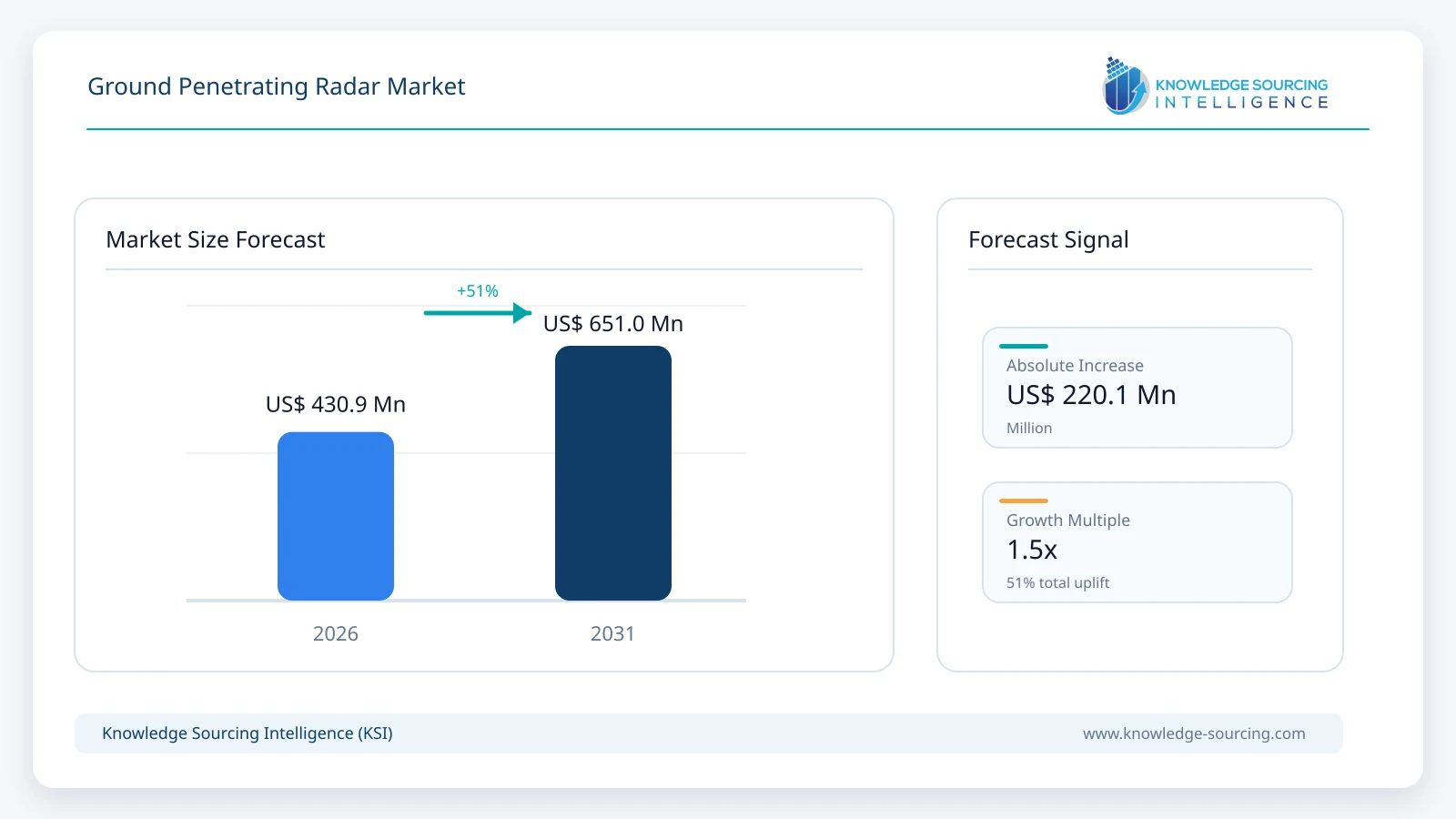
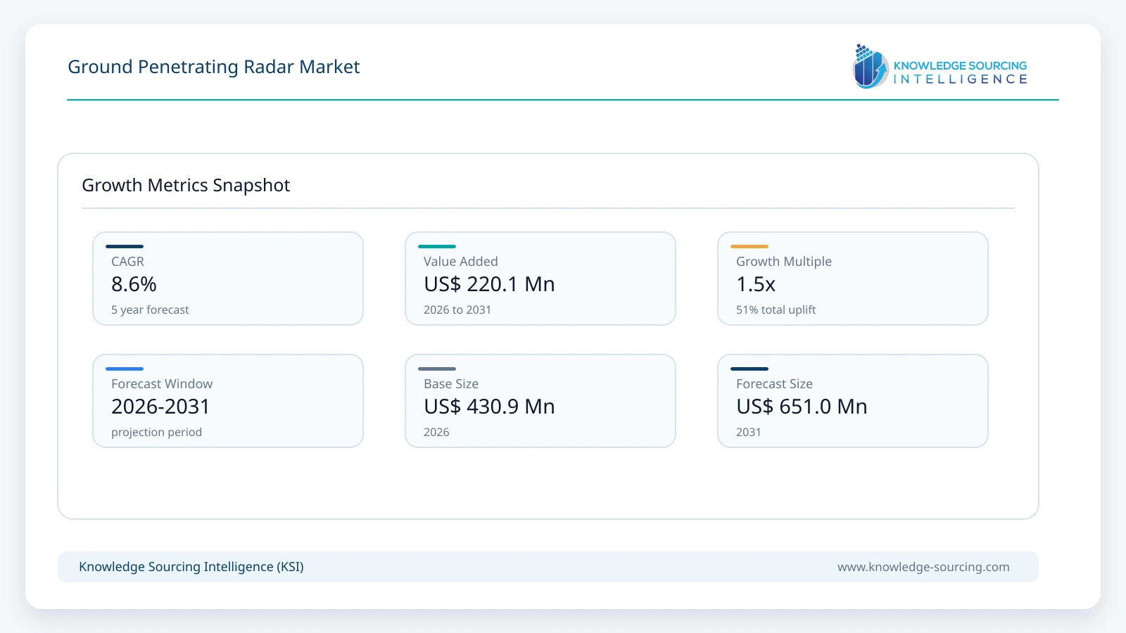
The ground penetrating radar market is forecast to grow at a CAGR of 8.6%, reaching USD 651.0 million in 2031 from USD 430.9 million in 2026.
Highlights:
- 1Cart-based systems account for approximately 39% of global market value in 2026, led by utility locating and general subsurface investigation.
- 2Equipment represents approximately 69% of the market in 2026, while software and services gain share as GPR workflows become more data-intensive.
- 3Mid-frequency systems account for approximately 45% of market value in 2026, balancing penetration depth with target resolution across common field applications.
- 4Construction and infrastructure account for approximately 36% of market demand in 2026, supported by concrete inspection, pavement assessment, and subsurface mapping.
- 5North America holds approximately 35% of the global market in 2026, supported by mature utility-locating, infrastructure inspection and defence applications.
- 6Drone-based and multi-channel 3D GPR systems are expected to expand faster than the overall market through 2031 from smaller installed bases.
Market Overview
| Report Metric | Details |
|---|---|
| Total Market Size in 2026 | USD 430.9 million |
| Total Market Size in 2031 | USD 651.0 million |
| Forecast Unit | Million |
| Growth Rate | 8.6% |
| Study Period | 2021 to 2031 |
| Historical Data | 2021 to 2024 |
| Base Year | 2025 |
| Forecast Period | 2026 – 2031 |
| Segmentation | Type, Offering, Frequency, End-User |
| Companies |
|
Ground penetrating radar (GPR) is a non-destructive geophysical method that transmits electromagnetic energy into the ground or a structure and records reflections generated by changes in dielectric properties. Modern systems are used to locate metallic and non-metallic utilities, map reinforcement and voids in concrete, measure pavement layers, assess bridge decks, investigate geological conditions, support archaeology and forensics, and detect buried threats. The technology is increasingly positioned as part of a broader subsurface intelligence workflow rather than as a standalone radar instrument. The U.S. Federal Highway Administration identifies GPR as a rapid, established non-destructive evaluation technique for underground utilities, bridge decks and pavements, with applications ranging from reinforcement mapping and deck-thickness measurement to utility detection and subsurface defect assessment.
Commercial systems now span compact handheld scanners, cart-based utility locators, vehicle-mounted multi-channel arrays and airborne platforms. Product development is improving both field productivity and interpretation. GSSI launched its Compass NX utility platform in September 2026 with dual-frequency operation, mobile-device control and integrated mapping, while Guideline Geo markets 3D MIRA arrays for large-area infrastructure and utility surveys and MALÅ GeoDrone for difficult or unsafe terrain. Software is also becoming more important as survey data are georeferenced, processed into 3D models and transferred into CAD, GIS and asset-management workflows. These changes expand the addressable market beyond specialist geophysics teams toward civil contractors, utility owners, transport agencies and survey professionals that require faster decisions in the field.
Market Trends
• Multi-Channel and 3D GPR Are Increasing Survey Productivity
The market is moving toward arrays that collect multiple closely spaced radar channels in a single pass, allowing users to generate more complete 3D subsurface models without manually repeating dense survey grids. Guideline Geo's MIRA family is designed around one-pass 3D mapping, while ImpulseRadar's Raptor platform targets high-speed road and infrastructure surveys. This is particularly important for utility mapping, pavement assessment, and large archaeological sites where survey productivity can determine project economics. The commercial value of these systems comes from reducing field time while increasing spatial coverage and the consistency of the resulting dataset.
• GNSS, Mobile Devices and Cloud Workflows Are Becoming Standard
GPR products increasingly combine radar data with precise positioning and digital project workflows. In March 2026, GSSI and Topcon announced an integration linking GSSI radar systems with Topcon GNSS positioning and mass-data workflow software for infrastructure and construction projects. Guideline Geo also integrated Trimble Catalyst positioning with the MALÅ Easy Locator Core during 2026. Screening Eagle's GS8000 similarly combines stepped-frequency radar, GNSS and direct CAD/GIS-oriented workflows. This integration reduces the separation between detection, surveying and reporting, making georeferenced deliverables increasingly important alongside raw radar performance.
• Airborne and Remote Platforms Are Expanding Access to Difficult Terrain
Drone-based GPR remains a smaller market category but is widening the environments in which radar can be deployed. Guideline Geo's MALÅ GeoDrone 600 is designed for near-surface investigations over snow, rocky ground, rivers and avalanche-prone terrain where conventional carts can be difficult or unsafe to operate. Vehicle-mounted platforms are simultaneously increasing productivity on roads and large sites. The resulting market is becoming more differentiated by mobility and workflow, with handheld systems optimized for confined structures, carts for routine utility and geotechnical surveys, vehicles for corridor mapping and drones for inaccessible terrain.
Segment Analysis
• By Type: Cart-Based Systems
Cart-based systems account for approximately 39% of market value in 2026 and remain the largest type category. They provide a practical balance between antenna size, battery capacity, positioning, display area and field mobility, making them widely used for utility locating, geotechnical investigation and general construction surveys. Current products increasingly combine dual-frequency antennas with mapping interfaces so shallow and deeper targets can be evaluated in the same survey. GSSI's Compass NX and UtilityScan platforms, Sensors & Software's LMX family, Guideline Geo's Easy Locator products and ImpulseRadar's PinPointR illustrate the continued depth of competition in this category.
• By Offering: Equipment
Equipment represents approximately 69% of global market value in 2026 because antennas, control electronics, carts and integrated positioning hardware remain the largest component of customer expenditure. The share is expected to moderate gradually as software, interpretation and specialist survey services become more important. GPR manufacturers increasingly sell an ecosystem rather than an isolated instrument, combining acquisition software, mapping, post-processing, cloud access, training and updates with hardware. This supports recurring revenue and expands the role of software without displacing the equipment base required to collect radar data.
• By Frequency: Mid Frequency
Mid-frequency systems, broadly between 500 MHz and 1 GHz, account for approximately 45% of market value in 2026. This range provides a useful balance between depth penetration and resolution for utility locating, construction, archaeology and geotechnical work. Lower-frequency antennas are preferred where greater depth is required, while high-frequency systems above 1 GHz are concentrated in concrete inspection, pavement and other shallow high-resolution applications. Multi-frequency and ultra-wideband systems are reducing the limitations of rigid frequency categories by collecting complementary information across multiple depth ranges in a single workflow.
• By End-User: Construction and Infrastructure
Construction and infrastructure account for approximately 36% of global demand in 2026. GPR is used before cutting, drilling or excavation, and during condition assessment of roads, bridges and concrete structures. FHWA identifies applications including rebar mapping, deck-thickness measurement, void identification, pavement layer assessment and subsurface utility detection. The value proposition is strongest where destructive testing, lane closures or accidental utility strikes carry high costs. The segment also benefits from infrastructure renewal programs, including the approximately USD 550 billion in new U.S. federal infrastructure investment authorized under the Infrastructure Investment and Jobs Act.
• By Geography: North America
North America accounts for approximately 35% of the global market in 2026. The United States combines a mature underground utility locating industry with extensive transport infrastructure, bridge and pavement inspection requirements, defence applications and a large professional surveying market. The region is also home to GSSI, Sensors & Software through SPX Technologies, US Radar and Chemring's GPR-based defence detection operations. Adoption is supported by established non-destructive evaluation practices and increasing integration of radar with GNSS, digital mapping and asset-management systems. Asia Pacific is expected to gain share through 2031 as infrastructure and government procurement expand in countries including China, India, South Korea and Malaysia.
Market Drivers
• Infrastructure Inspection and Rehabilitation Are Expanding Non-Destructive Testing
Aging transport and civil infrastructure increases the need for methods that can inspect assets without extensive coring, demolition or traffic disruption. FHWA identifies GPR among the most useful technologies for concrete bridge-deck assessment and describes it as a widely used method for pavement thickness, base and subbase defects and other infrastructure applications. Because vehicle-mounted systems can collect data while moving, GPR is particularly attractive for network-level road surveys where continuous information is more useful than isolated cores. Public infrastructure investment supports this demand by increasing both rehabilitation activity and requirements for quality assurance on new construction.
• Utility Mapping Is Becoming More Important as Underground Networks Become More Congested
Utility locating remains one of the most commercially important GPR applications because electromagnetic locators cannot reliably detect every non-metallic pipe, conduit or abandoned service. GPR can identify changes in subsurface conditions and map targets that do not carry an electrical signal, making it valuable alongside conventional locating technologies. Modern systems are increasingly designed around this combined field workflow, with real-time mapping, GPS coordinates, target marking and export to GIS or CAD. The launch of GSSI Compass NX in September 2026 reflects continuing investment in this market, with the platform designed specifically around shallow and deep utility visibility and mobile field documentation.
• Automation and Better Software Are Reducing Interpretation Friction
GPR historically required specialist interpretation, which restricted adoption outside geophysics teams. Software improvements are reducing this barrier through automated feature recognition, depth slicing, 3D visualization and clearer georeferenced outputs. Guideline Geo markets AI-enabled utility locating and 3D processing within its MALÅ ecosystem, while Sensors & Software, Screening Eagle, GSSI and ImpulseRadar maintain increasingly integrated acquisition and interpretation software. Automation does not remove the need for experienced operators, but it improves productivity and allows more routine applications to be completed by construction, survey and asset-management teams.
Market Restraints
• Subsurface Conditions Limit Detection Depth and Reliability
GPR performance varies substantially with soil conductivity, moisture, clay content, salinity, target size and antenna frequency. Highly conductive environments can attenuate electromagnetic energy quickly and reduce usable depth, while complex sites can generate reflections that are difficult to distinguish from the target of interest. FHWA notes that GPR results require appropriate calibration and can be negatively affected by conditions such as de-icing salts and material variability. Buyers therefore cannot select systems solely on advertised maximum depth; field conditions and application-specific antenna choices remain critical to performance.
• Equipment Cost and Operator Expertise Constrain Smaller Users
Professional GPR systems can require substantial upfront spending, especially when projects need multi-channel arrays, precision GNSS, software and specialist accessories. Interpretation also remains skill dependent. FHWA recommends experienced and qualified operators for infrastructure surveys and notes that GPR can be less cost-effective for smaller individual structures. Rental, service-based surveying and easier user interfaces partly address this constraint, but the need for training and ground-truth validation remains an important limitation for organizations that use GPR only occasionally.
Regional Outlook
• North America
North America remains the largest market through the near term, supported by utility mapping, infrastructure inspection, concrete scanning, geotechnical work and defence applications. The United States has an established regulatory and professional ecosystem for non-destructive evaluation, while major domestic suppliers continue to release new products and integrate GPR with surveying technology. Canada contributes through infrastructure, geotechnical and resource applications and is also the home market of Sensors & Software.
• Asia Pacific
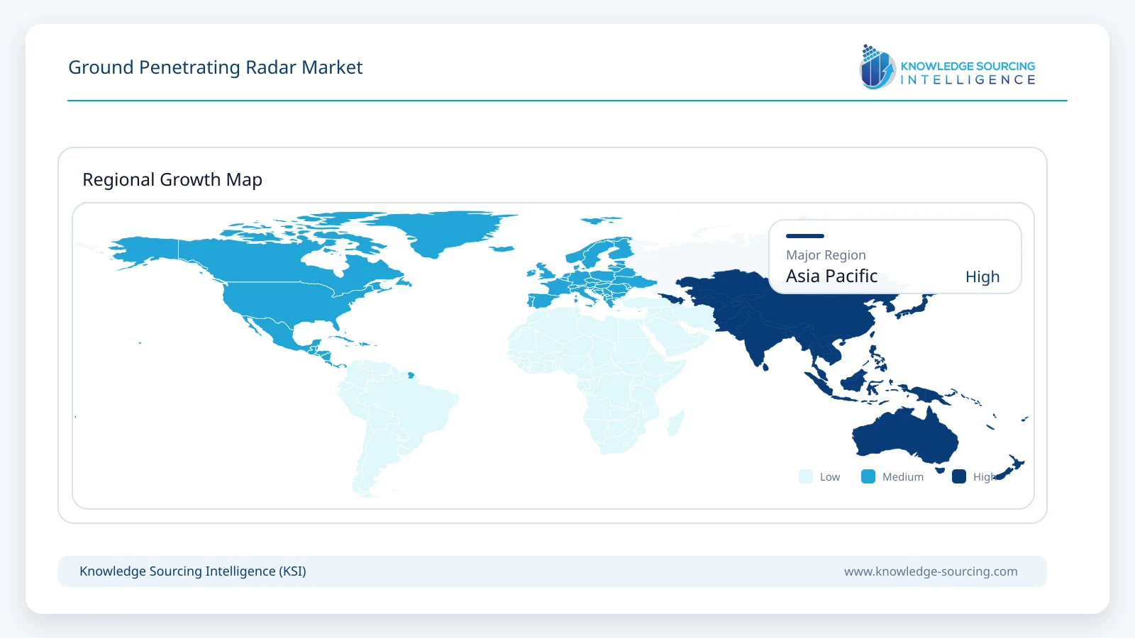
Asia Pacific is expected to record the strongest regional expansion through 2031 as urban infrastructure and subsurface mapping investment increase. Commercial evidence is visible in current procurement. Guideline Geo won a SEK 3.8 million government tender from the Korea Authority of Land and Infrastructure Safety in August 2026 covering multiple 2D and 3D GPR systems, after receiving a SEK 3.0 million Malaysian government order in July for solutions ranging from Easy Locator Core to vehicle-mounted MIRA HDR. These projects illustrate demand for both routine utility locating and high-capacity 3D infrastructure inspection.
Competitive Landscape
The GPR market is moderately fragmented, with competition spanning specialist radar manufacturers, broader geophysical-equipment groups and defence-sensor suppliers. GSSI remains a major commercial GPR manufacturer and is a wholly owned subsidiary of OYO Corporation, not SPX Technologies. SPX Technologies participates through Sensors & Software, which it acquired in 2020 and operates within its Detection & Measurement platform. Hexagon participates through IDS GeoRadar, while Guideline Geo, ImpulseRadar, Screening Eagle Technologies, US Radar and Groundradar address different combinations of utility, construction, road, geotechnical and survey applications. Chemring remains relevant in defence through vehicle-mounted and handheld GPR-based buried-threat detection. Competitive differentiation increasingly depends on software workflow, multi-channel imaging, positioning integration, usability and application support in addition to raw antenna specifications.
Recent Developments
September 2026: GSSI launched Compass NX, a next-generation dual-frequency utility locating platform powered by its Nexus software environment.
August 2026: Guideline Geo won a SEK 3.8 million South Korean government tender covering multiple GPR systems from 2D Easy Locator Core to 3D MIRA Compact.
July 2026: Guideline Geo received a SEK 3.0 million Malaysian government order for a broad GPR portfolio including vehicle-mounted MIRA HDR.
March 2026: GSSI and Topcon announced an integration combining GPR, GNSS positioning and mass-data workflow software for infrastructure and construction projects.
March 2026: Guideline Geo introduced MALÅ MIRA Flex, a modular 3D GPR array intended for integration into specialized customer platforms.
Market Outlook
The ground penetrating radar market is expected to expand through 2031 as subsurface information becomes more closely integrated with construction, surveying and infrastructure-management workflows. Cart-based systems and equipment remain the largest revenue pools, while software, 3D arrays, drone-based platforms and service-based delivery expand faster from smaller bases. Utility detection and infrastructure assessment provide the broadest recurring commercial demand, while defence, archaeology, mining and environmental applications sustain specialist system requirements. The market is forecast to increase from USD 430.9 million in 2026 to USD 651.0 million by 2031, with growth increasingly determined by workflow productivity and data quality rather than radar hardware specifications alone.
Market Segmentation
By Type
Handheld Systems
Cart-Based Systems
Vehicle-Mounted Systems
Drone-Based Systems
By Offering
Equipment
Software
Services
By Frequency
Low Frequency (<500 MHz)
Mid Frequency (500 MHz–1 GHz)
High Frequency (>1 GHz)
By End-User
Construction and Infrastructure
Utility Detection
Oil & Gas and Mining
Government and Military
Archaeology and Research
By Geography
North America
United States
Canada
Mexico
South America
Brazil
Argentina
Others
Europe
Germany
United Kingdom
France
Spain
Italy
Others
Middle East and Africa
Saudi Arabia
UAE
Others
Asia Pacific
China
Japan
India
South Korea
Indonesia
Others
Table of Contents
1. EXECUTIVE SUMMARY
2. MARKET SNAPSHOT
2.1. Market Overview
2.2. Market Definition
2.3. Scope of the Study
2.4. Market Segmentation
3. BUSINESS LANDSCAPE
3.1. Market Drivers
3.1.1. Infrastructure Inspection and Rehabilitation
3.1.2. Underground Utility Detection and Mapping
3.1.3. Automation, GNSS Integration and Digital Workflows
3.2. Market Restraints
3.2.1. Subsurface Conductivity and Environmental Limitations
3.2.2. Equipment Cost and Skilled-Operator Requirements
3.3. Market Opportunities
3.4. Porter’s Five Forces Analysis
3.5. Industry Value Chain Analysis
3.6. GPR Technology and Workflow Trends
3.7. Policies and Regulations
3.8. Strategic Recommendations
4. GROUND PENETRATING RADAR MARKET BY TYPE
4.1. Introduction
4.2. Handheld Systems
4.3. Cart-Based Systems
4.4. Vehicle-Mounted Systems
4.5. Drone-Based Systems
5. GROUND PENETRATING RADAR MARKET BY OFFERING
5.1. Introduction
5.2. Equipment
5.3. Software
5.4. Services
6. GROUND PENETRATING RADAR MARKET BY FREQUENCY
6.1. Introduction
6.2. Low Frequency (<500 MHz)
6.3. Mid Frequency (500 MHz-1 GHz)
6.4. High Frequency (>1 GHz)
7. GROUND PENETRATING RADAR MARKET BY END-USER
7.1. Introduction
7.2. Construction and Infrastructure
7.3. Utility Detection
7.4. Oil & Gas and Mining
7.5. Government and Military
7.6. Archaeology and Research
8. GROUND PENETRATING RADAR MARKET BY GEOGRAPHY
8.1. North America
8.1.1. United States
8.1.2. Canada
8.1.3. Mexico
8.2. South America
8.2.1. Brazil
8.2.2. Argentina
8.2.3. Others
8.3. Europe
8.3.1. Germany
8.3.2. United Kingdom
8.3.3. France
8.3.4. Spain
8.3.5. Italy
8.3.6. Others
8.4. Middle East and Africa
8.4.1. Saudi Arabia
8.4.2. UAE
8.4.3. Others
8.5. Asia Pacific
8.5.1. China
8.5.2. Japan
8.5.3. India
8.5.4. South Korea
8.5.5. Indonesia
8.5.6. Others
9. COMPETITIVE ENVIRONMENT AND ANALYSIS
9.1. Major Players and Strategy Analysis
9.2. Product and Technology Positioning
9.3. Multi-Channel and 3D GPR Capabilities
9.4. Software, GNSS and Workflow Integration
9.5. Mergers, Acquisitions, Agreements and Collaborations
9.6. Competitive Dashboard
10. COMPANY PROFILES
10.1. Geophysical Survey Systems, Inc. (GSSI)
10.2. IDS GeoRadar
10.3. Guideline Geo AB
10.4. Sensors & Software Inc.
10.5. ImpulseRadar Sweden AB
10.6. Screening Eagle Technologies AG
10.7. Chemring Sensors & Electronic Systems
10.8. US Radar Inc.
10.9. Groundradar Inc.
10.10. Radar Systems, Inc.
Research Methodology
The market is analyzed using a combination of top-down and bottom-up approaches. The global market total is assessed using manufacturer product portfolios, equipment pricing and replacement cycles, public-company and parent-company disclosures, distributor activity, government and infrastructure procurement, application-level adoption and demand across utility, construction, transport, geotechnical and defence workflows. Segment estimates are reconciled against the global total rather than generated by applying one uniform growth rate across all categories.
Forecast assumptions incorporate increasing penetration of multi-frequency and multi-channel systems, expansion of software and service revenue, infrastructure inspection demand, utility-locating requirements, regional construction and transport investment, and the adoption of vehicle-mounted and drone-based platforms. Company announcements and official transportation and infrastructure sources are used to validate application trends and technology adoption. Third-party market-research estimates are not used as the primary sizing engine.
Navigate
Trusted by the world's leading organizations