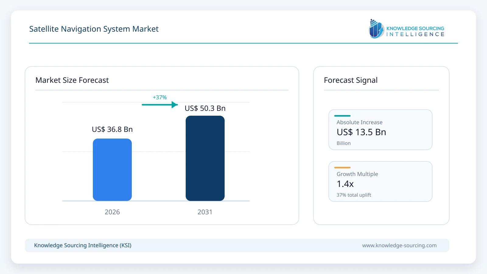
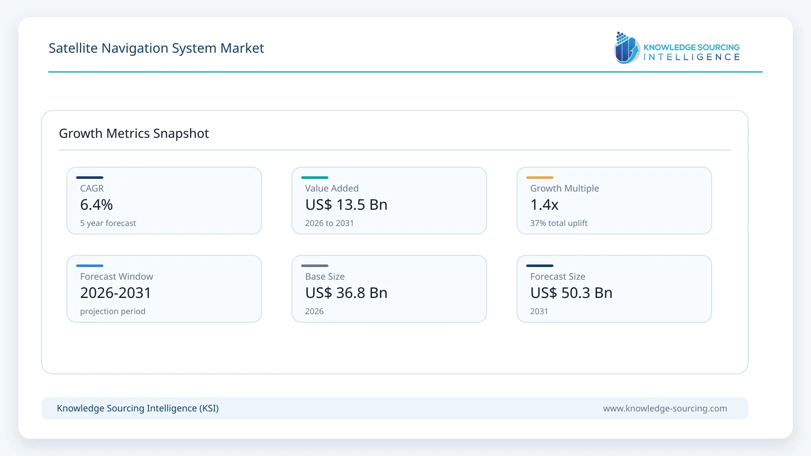
The Satellite Navigation System market is projected to grow at a CAGR of 6.4%, reaching USD 50.3 billion in 2031 from USD 36.8 billion in 2026.
Highlights:
- 1Global navigation satellite systems account for approximately 91% of satellite navigation system market value in 2026, reflecting the worldwide reach of GPS, Galileo, BeiDou and GLONASS.
- 2The user segment accounts for approximately 66% of market value in 2026 as receivers, antennas, chipsets and navigation equipment are deployed across billions of consumer and professional devices.
- 3Transportation represents approximately 28% of market value in 2026, supported by road navigation, fleet management, aviation, maritime operations, rail and commercial logistics.
- 4North America accounts for approximately 31% of global market value in 2026, supported by the GPS ecosystem, defense applications and a large base of navigation technology suppliers.
- 5Asia Pacific is projected to be the fastest-growing regional market at approximately 8.0% annually through 2031 as China, Japan, India and South Korea expand navigation infrastructure and downstream adoption.
The market covers global navigation satellite systems including GPS, Galileo, BeiDou and GLONASS; regional navigation systems including NavIC and QZSS; space, ground and user-segment infrastructure; and associated navigation equipment deployed across transportation, defense, consumer electronics, automotive and industrial applications.
The commercial importance of satellite navigation extends substantially beyond the satellites themselves. EUSPA reported that approximately 5.8 billion GNSS-enabled devices were in use globally in 2024 and expects the installed base to approach 10 billion units by 2034. Consumer solutions and road and automotive applications account for the majority of mass-market GNSS adoption, while professional applications including agriculture, infrastructure, aviation, maritime operations and surveying support higher-value precise-positioning equipment and services.
Market Overview
Satellite navigation systems provide position, navigation and timing information by transmitting precisely timed signals from orbiting satellites to receivers on or near Earth. Modern receivers increasingly combine signals from multiple constellations rather than depending on a single system, improving satellite availability, accuracy and resilience in urban, mountainous and other difficult environments.
The global infrastructure base continues to modernize. As of May 19, 2026, the U.S. GPS constellation included 39 satellites, of which 32 were set healthy, compared with a baseline constellation requirement of 24 satellites. GPS III represented the newest operational block, while average weighted signal-in-space user range error over the preceding year was 30.8 centimeters.
Europe’s Galileo constellation has also expanded. Two additional satellites entered operational service in July 2026, while ESA reported that Galileo consists of more than 30 satellites and serves more than five billion users worldwide. Twelve Galileo Second Generation satellites are planned to join the existing fleet, with Airbus Defence and Space and Thales Alenia Space each responsible for six spacecraft.
Regional systems are strengthening the wider market. India’s NavIC is designed to provide independent PNT services over India and approximately 1,500 km beyond the country’s landmass, while five second-generation NVS satellites are planned to augment the system and introduce L1-band signals. Japan is expanding QZSS, with QZS-7 launched in August 2026 as the programme progresses toward a larger independent regional navigation capability. South Korea is developing the Korea Positioning System with a target of centimeter-level positioning services over the Korean Peninsula and surrounding region.
Market Trends
Multi-Frequency GNSS Is Moving Into Broader Device Categories
GNSS receivers have evolved from basic single-frequency positioning toward multi-constellation and multi-frequency architectures capable of correcting ionospheric errors and obtaining higher-quality positioning under difficult signal conditions. This development is reducing the distinction between conventional navigation receivers and equipment historically reserved for survey-grade precise positioning.
Qualcomm introduced the X105 modem-RF platform in March 2026 with quad-band GNSS support. The platform adds the L6 band used by Galileo and QZSS, allowing receivers to access high-accuracy correction information directly from navigation satellites. Qualcomm states that its latest positioning architecture can deliver decimeter- to centimeter-level performance in suitable configurations while reducing GNSS power consumption by approximately 25% compared with the previous generation.
u-blox has similarly expanded all-band positioning through the ZED-X20P-01B, which incorporates Galileo High Accuracy Service support and global precise point positioning, while its ZED-X20K and ZED-A20K modules target automotive applications ranging from advanced driver assistance to higher levels of automated driving.
Resilient PNT Is Becoming a Core Product Requirement
GNSS receiver specifications increasingly emphasize resistance to intentional jamming and spoofing rather than accuracy alone. This shift is particularly visible in defense, aviation, maritime, autonomous systems and critical infrastructure where loss or manipulation of navigation data can disrupt operations.
Trimble introduced its Maxwell 8 receiver architecture in September 2026 with new anti-jamming and anti-spoofing capabilities, expanded multi-frequency tracking and four times the processing capability of its predecessor. Septentrio launched the 2.2-gram mosaic-G5 P8 module in May 2026 for UAV, rail, maritime and defense applications requiring centimeter-level RTK positioning and enhanced interference protection.
The competitive requirement is increasingly moving toward assured PNT, where GNSS is combined with inertial sensors, terrestrial signals and other navigation sources. Hexagon strengthened this position in April 2026 through its acquisition of Inertial Sense, which had more than 30,000 GNSS-plus-inertial systems deployed across commercial and defense applications.
LEO Navigation Is Emerging as a Complementary Layer
Traditional GPS, Galileo, GLONASS and BeiDou satellites operate principally in medium Earth orbit, while regional systems also use geostationary and inclined geosynchronous orbits. A complementary low-Earth-orbit navigation layer is now being tested as a means of providing stronger signals, faster geometry changes and additional resilience.
ESA launched the first two satellites of its Celeste demonstration programme on March 28, 2026. The mission is designed to test a complementary LEO positioning layer for Galileo using new L- and S-band signals and evaluate how a closer orbital layer can strengthen positioning performance and resilience.
Receiver suppliers are already preparing for this architecture. Trimble’s Maxwell 8 receivers include future support for emerging LEO navigation signals, demonstrating how receiver roadmaps are beginning to anticipate hybrid MEO-LEO positioning rather than relying exclusively on conventional GNSS constellations.
Sovereign and Regional Navigation Infrastructure Is Expanding
Positioning and timing are increasingly regarded as national infrastructure rather than purely commercial services. The United States, European Union, China, India, Japan and South Korea are investing in independent or sovereign PNT capabilities to reduce reliance on foreign systems and strengthen resilience.
Japan’s QZSS reached an important expansion milestone with the August 2026 launch of QZS-7. South Korea’s KPS programme targets centimeter-level positioning and includes dedicated navigation satellites, operations centers, monitoring stations and user receivers. India’s second-generation NavIC programme adds L1 signals intended to broaden receiver compatibility.
Market Drivers
Expansion of the GNSS-Enabled Device Base
The most important volume driver is the continued proliferation of satellite-navigation capability across smartphones, vehicles, wearables, drones and industrial equipment. EUSPA estimates that 5.8 billion GNSS-enabled devices were in use globally in 2024 and expects the installed base to approach 10 billion by 2034. Consumer solutions and road and automotive applications account for the majority of device shipments and installed units.
The significance extends beyond device volumes because newer receivers increasingly support several constellations and frequencies. This raises semiconductor, antenna and software requirements while allowing high-accuracy navigation to expand beyond traditional surveying equipment into vehicles, drones and connected industrial systems.
Modernization of Sovereign Navigation Infrastructure
Major navigation operators are simultaneously upgrading satellite and ground infrastructure. The U.S. GPS programme had 32 healthy satellites as of May 2026 and is transitioning from GPS III toward GPS IIIF, including a June 2026 USD 514.4 million order for two additional spacecraft. Galileo has more than 30 satellites and plans to add 12 second-generation spacecraft, while Japan, India and South Korea are expanding or developing regional systems.
These programmes create recurring demand across satellite manufacturing, atomic clocks, navigation payloads, control infrastructure, antennas, monitoring networks and specialized user equipment rather than representing one-time constellation deployments.
Movement Toward Centimeter-Level Positioning
High-accuracy positioning is moving from specialized surveying into automotive, autonomous machines, drones and mass-market connected equipment. Galileo High Accuracy Service is designed to support horizontal accuracy around 20 centimeters and vertical accuracy around 40 centimeters under targeted service conditions, while new receivers can combine these corrections with multiple satellite frequencies and inertial sensors.
Qualcomm’s 2026 X105 platform adds quad-frequency GNSS and reports a 25% reduction in navigation power consumption compared with the previous generation. Such advances make continuous precise positioning more economically practical for battery-powered and high-volume devices.
Market Restraints
Rapid Increase in GNSS Jamming and Spoofing
Satellite navigation signals are extremely weak when they reach Earth, making receivers vulnerable to intentional and accidental radio-frequency interference. EUROCONTROL recorded 4,353 GNSS jamming cases and 1,132 spoofing cases in 2025 through its EVAIR reporting framework, compared with 2,324 jamming and 539 spoofing cases in 2024.
The increasing threat is changing equipment requirements across aviation, defense, maritime systems and autonomous platforms. EASA issued an updated GNSS interference Safety Information Bulletin in July 2026 after analysing recent jamming and spoofing events, while EASA and EUROCONTROL published a joint action plan earlier in the year covering operational procedures, detection and resilient navigation infrastructure.
Higher interference therefore supports investment in resilient PNT but simultaneously raises receiver complexity, qualification requirements and system cost.
Constellation Deployment and Replenishment Carry Significant Programme Risk
Navigation constellations require long-duration satellite manufacturing, launch, orbit raising, ground-control integration and service qualification. Failure at any stage can delay capacity additions for several years.
India’s NVS-02 illustrates this risk. The satellite was successfully injected into transfer orbit in January 2025, but orbit raising could not be completed because the required signal did not reach the oxidizer-line pyro valve. ISRO’s February 2026 investigation identified connector contact disengagement as the most likely cause, and the satellite remains listed as non-operational for PNT service.
The financial exposure is substantial even for mature programmes. The U.S. Space Force’s June 2026 contract for only two GPS IIIF satellites was valued at USD 514.4 million, while additional investments are required for launch and ground-control modernization.
Segment Analysis
By Type of System: Global Navigation Satellite Systems
GNSS remains the principal system category because GPS, Galileo, BeiDou and GLONASS provide global or near-global positioning coverage and are integrated into mass-market chipsets and professional navigation equipment. Modern receivers commonly process signals from several constellations simultaneously, reducing dependence on any single satellite network.
The GNSS segment is projected to reach approximately USD 45.0 billion by 2031. Growth is supported by continued GPS and Galileo modernization, broader BeiDou adoption and the transition from dual-frequency toward triple- and quad-frequency receiver designs.
GPS modernization remains particularly important to the space and ground segments. The U.S. Space Force launched the tenth and final GPS III spacecraft in April 2026 and subsequently awarded Lockheed Martin USD 514.4 million for GPS IIIF satellites 23 and 24, increasing the number of GPS IIIF spacecraft on contract to 14.
By Component: User Segment
The user segment encompasses navigation receivers, chipsets, antennas and associated equipment required to convert satellite signals into actionable position, navigation and timing information. Its scale is substantially larger than the number of satellites or control facilities because receivers are installed across smartphones, vehicles, aircraft, ships, drones, industrial equipment, surveying systems and critical infrastructure.
The segment is projected to reach approximately USD 33.4 billion by 2031, representing an annual growth rate of about 6.6% during the forecast period. Product value is moving upward in professional applications as users adopt multi-band receivers, inertial integration, correction services and anti-jamming capabilities, while mass-market semiconductor integration continues to reduce the cost of basic navigation.
EUSPA expects the global installed base of GNSS-enabled devices to increase from 5.8 billion in 2024 to almost 10 billion by 2034, providing a substantial underlying hardware base for satellite navigation services and applications.
By End-User Industry: Transportation
Transportation covers road vehicles, commercial fleets, aviation, maritime operations, rail and logistics and remains one of the largest professional and mass-market uses of satellite navigation. Applications range from basic route guidance and asset tracking to aircraft navigation, maritime positioning and high-integrity automotive localization.
Transportation-related satellite navigation revenue is projected to reach approximately USD 13.9 billion by 2031. Increasing requirements for lane-level positioning, automated driving, fleet optimization and resilient aviation navigation are raising the technical requirements of installed receivers.
Automotive GNSS is moving rapidly toward integrated positioning systems that combine satellite, inertial and vehicle sensor data. Qualcomm’s automotive positioning platform supports GNSS, dead reckoning and centimeter-to-decimeter correction services, while u-blox’s 2026 automotive modules target both L2+ ADAS and safety-critical L3/L4 vehicle architectures.
Regional Outlook
North America
North America is the largest satellite navigation system market in 2026, supported by the scale of the U.S. GPS programme, military PNT demand, automotive and aviation adoption and a large commercial positioning ecosystem spanning chipsets, professional receivers, navigation software and correction technologies.
The regional market is projected to reach approximately USD 15.1 billion by 2031. GPS modernization remains a major source of upstream expenditure. The final GPS III spacecraft was launched in April 2026, while the programme is transitioning to GPS IIIF, which introduces stronger anti-jamming capability and additional resilience features. The U.S. also contains leading commercial navigation suppliers including Garmin, Trimble, Qualcomm, Broadcom, Lockheed Martin, Northrop Grumman and RTX.
Commercial adoption extends far beyond dedicated navigation equipment. GPS supports aviation, maritime activity, telecommunications timing, emergency services and vehicle navigation, while more advanced receiver architectures are expanding use in autonomous vehicles, drones, construction and precision industrial applications.
Asia Pacific
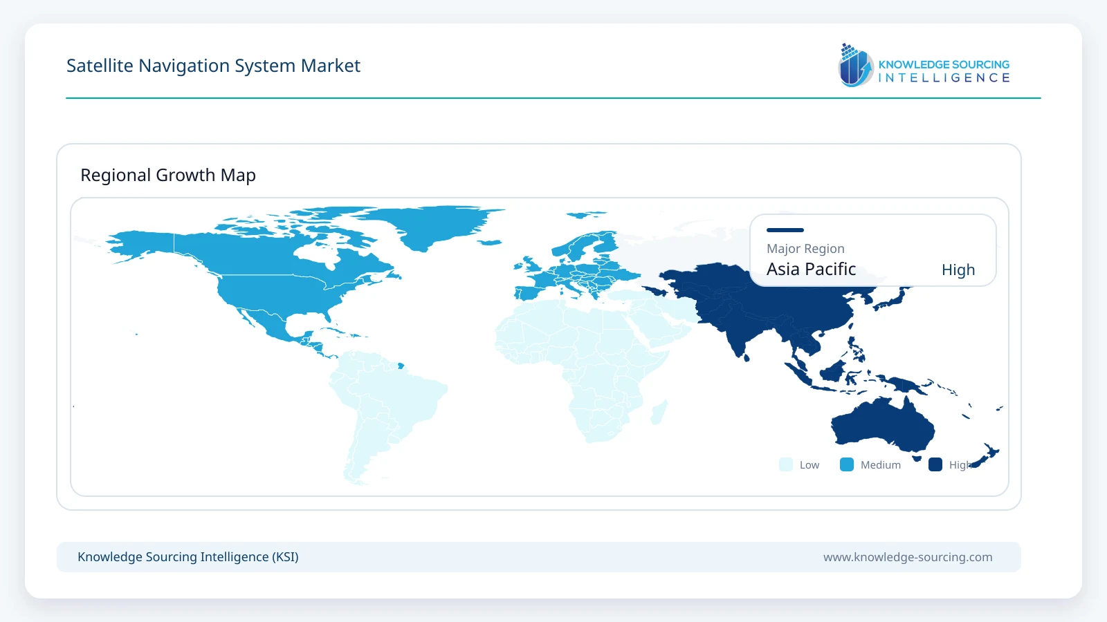
Asia Pacific is projected to be the fastest-growing regional market, expanding at approximately 8.0% annually from 2026 to 2031. Its market value is projected to reach approximately USD 16.2 billion by 2031 as regional navigation programmes mature and the installed base of consumer, automotive and industrial receivers continues to expand.
China operates the global BeiDou system, which is used across transportation, agriculture, forestry, fisheries, communications, power dispatch and mass-market consumer applications. Japan launched QZS-7 in August 2026 as part of the expansion of QZSS, while India is developing its second generation of NavIC satellites and South Korea continues development of KPS.
The region also contains a substantial share of global smartphone, automotive and electronics manufacturing, allowing new multi-frequency GNSS capabilities to move rapidly into high-volume products.
Competitive Landscape
The satellite navigation system market contains distinct but increasingly interconnected layers. Satellite and ground-system suppliers such as Lockheed Martin, Northrop Grumman, Airbus, Thales and RTX participate in sovereign navigation infrastructure, while Trimble, Hexagon, Garmin, Septentrio, u-blox and Topcon compete in professional positioning equipment. Qualcomm, Broadcom, STMicroelectronics and other semiconductor suppliers extend navigation capability into automotive, mobile and connected devices.
Lockheed Martin maintains a central position in GPS satellite manufacturing and ground-segment modernization. The company completed production of the ten-satellite GPS III block and is manufacturing the GPS IIIF generation, with 14 IIIF satellites under contract as of June 2026.
Airbus and Thales Alenia Space hold important positions in Europe’s next-generation infrastructure, with each company producing six Galileo Second Generation satellites. Hexagon has expanded its resilient PNT capabilities through Septentrio and the 2026 acquisition of Inertial Sense, while Trimble continues strengthening its high-precision professional receiver portfolio.
Competition in the user segment is increasingly determined by the ability to combine multi-constellation reception, additional frequency bands, correction services, inertial sensing and interference protection within smaller and more power-efficient hardware.
Recent Developments
September 2026: Trimble introduced BD1090, BD1092, BD1092i and BX1092i GNSS receivers using its new Maxwell 8 architecture, adding expanded anti-jamming, anti-spoofing, multi-frequency and future LEO-PNT capabilities.
September 2026: Lockheed Martin announced USD 114 million of additional U.S. Space Force work to modernize the GPS ground segment for GPS IIIF operations and refresh existing control infrastructure.
August 2026: Japan launched QZS-7 aboard H3 Flight 9 as part of the continuing expansion of the Quasi-Zenith Satellite System.
July 2026: ESA announced that Galileo SAT 33 and SAT 34 had entered service, strengthening the operational constellation ahead of further first-generation and second-generation deployments.
June 2026: The U.S. Space Force awarded a USD 514.4 million option for GPS IIIF satellites 23 and 24, bringing the contracted GPS IIIF fleet to 14 spacecraft.
May 2026: Septentrio introduced the mosaic-G5 P8 multi-frequency GNSS module for mission-critical applications requiring centimeter-level positioning and enhanced jamming and spoofing resistance.
April 2026: The U.S. Space Force launched the final GPS III spacecraft, SV10, completing the ten-satellite GPS III production block.
March 2026: ESA launched the first two Celeste satellites to demonstrate a complementary LEO navigation layer for Galileo.
Market Outlook
The satellite navigation system market is forecast to increase. Market growth is increasingly being driven by modernization and performance requirements rather than simply expansion of basic geographic coverage.
Global GNSS constellations remain the central infrastructure layer, while regional systems increase their contribution as governments seek independent and resilient positioning capability. The transition toward GPS IIIF, Galileo Second Generation, expanded QZSS, second-generation NavIC and eventual KPS deployment creates sustained requirements across satellites, payloads, atomic clocks, monitoring stations and ground-control systems.
The larger commercial opportunity is increasingly concentrated in the user segment. Multi-band receivers, precise point positioning, inertial integration and anti-jamming technologies are moving capabilities previously limited to survey and defense equipment into automotive, drones, industrial automation and other high-volume applications.
North America remains the largest regional market at the beginning of the forecast period, while Asia Pacific grows faster and is expected to become increasingly important as sovereign navigation systems, automotive electronics and industrial positioning applications expand.
Interference resilience is expected to become one of the most important competitive differentiators through 2031. The sharp increase in reported jamming and spoofing incidents is accelerating demand for multi-constellation receivers, inertial backup, authentication, interference monitoring and alternative PNT technologies alongside conventional satellite navigation.
Satellite Navigation System Market Scope
| Report Metric | Details |
|---|---|
| Total Market Size in 2026 | USD 36.8 billion |
| Total Market Size in 2031 | USD 50.3 billion |
| Forecast Unit | Billion |
| Growth Rate | 6.4% |
| Study Period | 2021 to 2031 |
| Historical Data | 2021 to 2024 |
| Base Year | 2025 |
| Forecast Period | 2026 – 2031 |
| Segmentation | Type of System, Component, End-User Industry, Geography |
| Companies |
|
Market Segmentation
By Type of System
Global Navigation Satellite Systems
GPS
GLONASS
Galileo
BeiDou
Regional Navigation Satellite Systems
NavIC
QZSS
By Component
Space Segment
Ground Segment
User Segment
By End-User Industry
Transportation
Defense and Security
Consumer Electronics
Automotive
Industrial
Others
By Geography
North America
United States
Canada
Mexico
South America
Brazil
Argentina
Others
Europe
United Kingdom
Germany
France
Spain
Others
Middle East and Africa
Saudi Arabia
UAE
Others
Asia Pacific
China
Japan
India
South Korea
Taiwan
Others
Table of Contents
1. INTRODUCTION
1.1. Market Overview
1.2. Market Definition
1.3. Scope of the Study
1.4. Market Segmentation
1.5. Currency
1.6. Assumptions
1.7. Base and Forecast Years
1.8. Key Benefits to Stakeholders
2. RESEARCH METHODOLOGY
2.1. Research Design
2.2. Secondary Research
2.3. Primary Research
2.4. Market Estimation
2.5. Segment Modelling
2.6. Data Triangulation and Validation
3. EXECUTIVE SUMMARY
3.1. Key Findings
3.2. Satellite Navigation System Market Size, 2026-2031
3.3. System Type Outlook
3.4. Component Outlook
3.5. End-User Outlook
3.6. Regional Opportunity Summary
4. MARKET DYNAMICS
4.1. Market Drivers
4.1.1. Expansion of the GNSS-Enabled Device Base
4.1.2. Modernization of Sovereign Navigation Infrastructure
4.1.3. Movement Toward Centimeter-Level Positioning
4.2. Market Restraints
4.2.1. Rapid Increase in GNSS Jamming and Spoofing
4.2.2. Constellation Deployment and Replenishment Risk
4.3. Market Opportunities
4.4. Porter’s Five Forces Analysis
4.5. Industry Value Chain Analysis
4.6. Policies and Regulations
4.7. Strategic Recommendations
5. TECHNOLOGICAL OUTLOOK
5.1. Multi-Constellation and Multi-Frequency GNSS
5.2. High-Accuracy and Precise Point Positioning
5.3. Assured and Resilient PNT
5.4. GNSS and Inertial Sensor Fusion
5.5. LEO-Based PNT
5.6. Anti-Jamming and Anti-Spoofing Technologies
6. SATELLITE NAVIGATION SYSTEM MARKET BY TYPE OF SYSTEM
6.1. Introduction
6.2. Global Navigation Satellite Systems
6.2.1. GPS
6.2.2. GLONASS
6.2.3. Galileo
6.2.4. BeiDou
6.3. Regional Navigation Satellite Systems
6.3.1. NavIC
6.3.2. QZSS
7. SATELLITE NAVIGATION SYSTEM MARKET BY COMPONENT
7.1. Introduction
7.2. Space Segment
7.3. Ground Segment
7.4. User Segment
8. SATELLITE NAVIGATION SYSTEM MARKET BY END-USER INDUSTRY
8.1. Introduction
8.2. Transportation
8.3. Defense and Security
8.4. Consumer Electronics
8.5. Automotive
8.6. Industrial
8.7. Others
9. SATELLITE NAVIGATION SYSTEM MARKET BY GEOGRAPHY
9.1. North America
9.1.1. United States
9.1.2. Canada
9.1.3. Mexico
9.2. South America
9.2.1. Brazil
9.2.2. Argentina
9.2.3. Others
9.3. Europe
9.3.1. United Kingdom
9.3.2. Germany
9.3.3. France
9.3.4. Spain
9.3.5. Others
9.4. Middle East and Africa
9.4.1. Saudi Arabia
9.4.2. UAE
9.4.3. Others
9.5. Asia Pacific
9.5.1. China
9.5.2. Japan
9.5.3. India
9.5.4. South Korea
9.5.5. Taiwan
9.5.6. Others
10. COMPETITIVE ENVIRONMENT AND ANALYSIS
10.1. Major Players and Strategy Analysis
10.2. Market Share Analysis
10.3. Mergers, Acquisitions, Agreements, and Collaborations
10.4. Competitive Dashboard
11. COMPANY PROFILES
11.1. Garmin Ltd.
11.2. Trimble Inc.
11.3. Hexagon AB
11.4. Qualcomm Technologies, Inc.
11.5. Broadcom Inc.
11.6. u-blox Holding AG
11.7. Septentrio N.V.
11.8. Topcon Corporation
11.9. STMicroelectronics N.V.
11.10. Lockheed Martin Corporation
11.11. Northrop Grumman Corporation
11.12. RTX Corporation
11.13. Airbus SE
11.14. Thales Group
11.15. L3Harris Technologies, Inc.
11.16. SpaceX
Navigate
Trusted by the world's leading organizations