
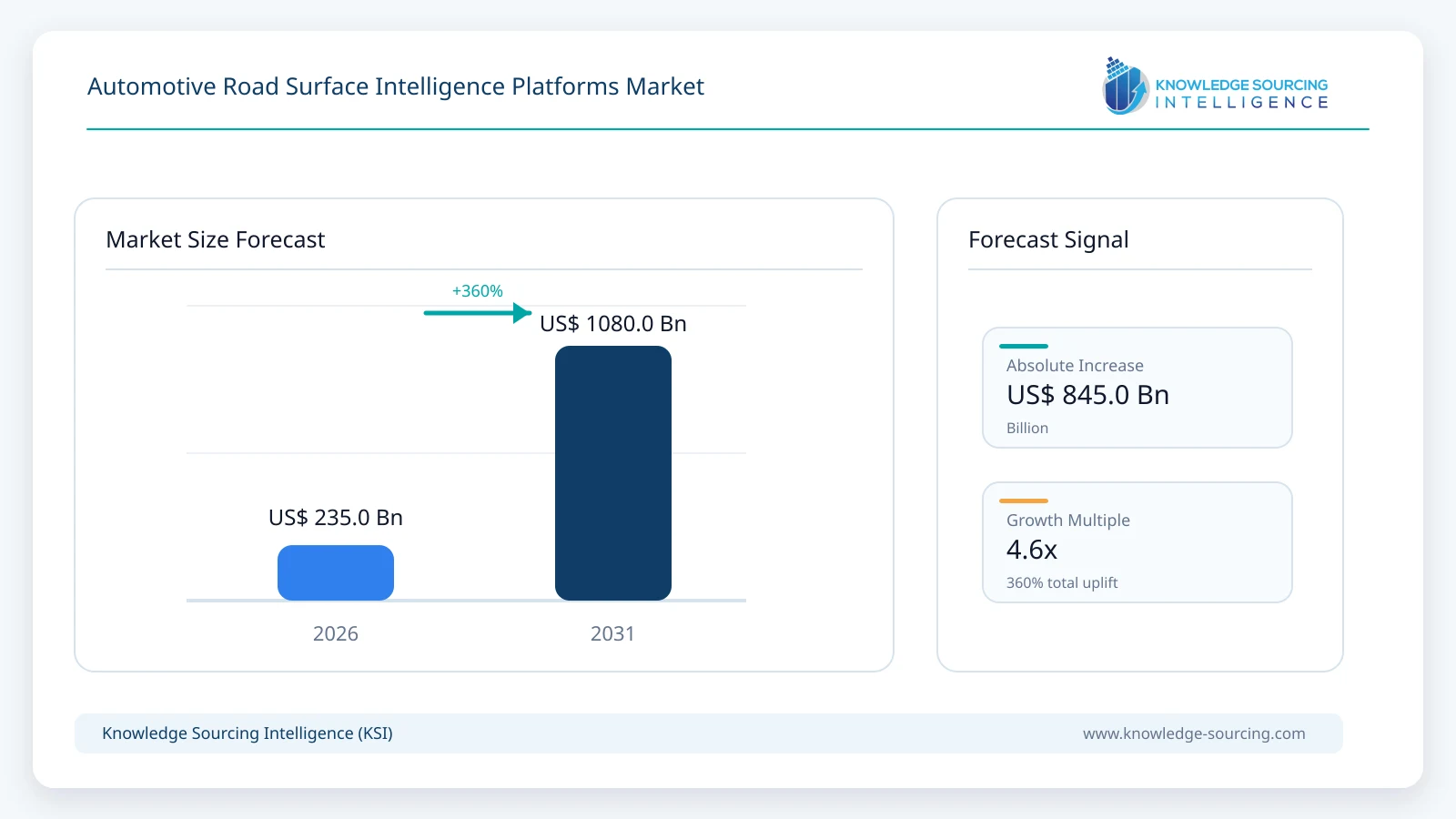
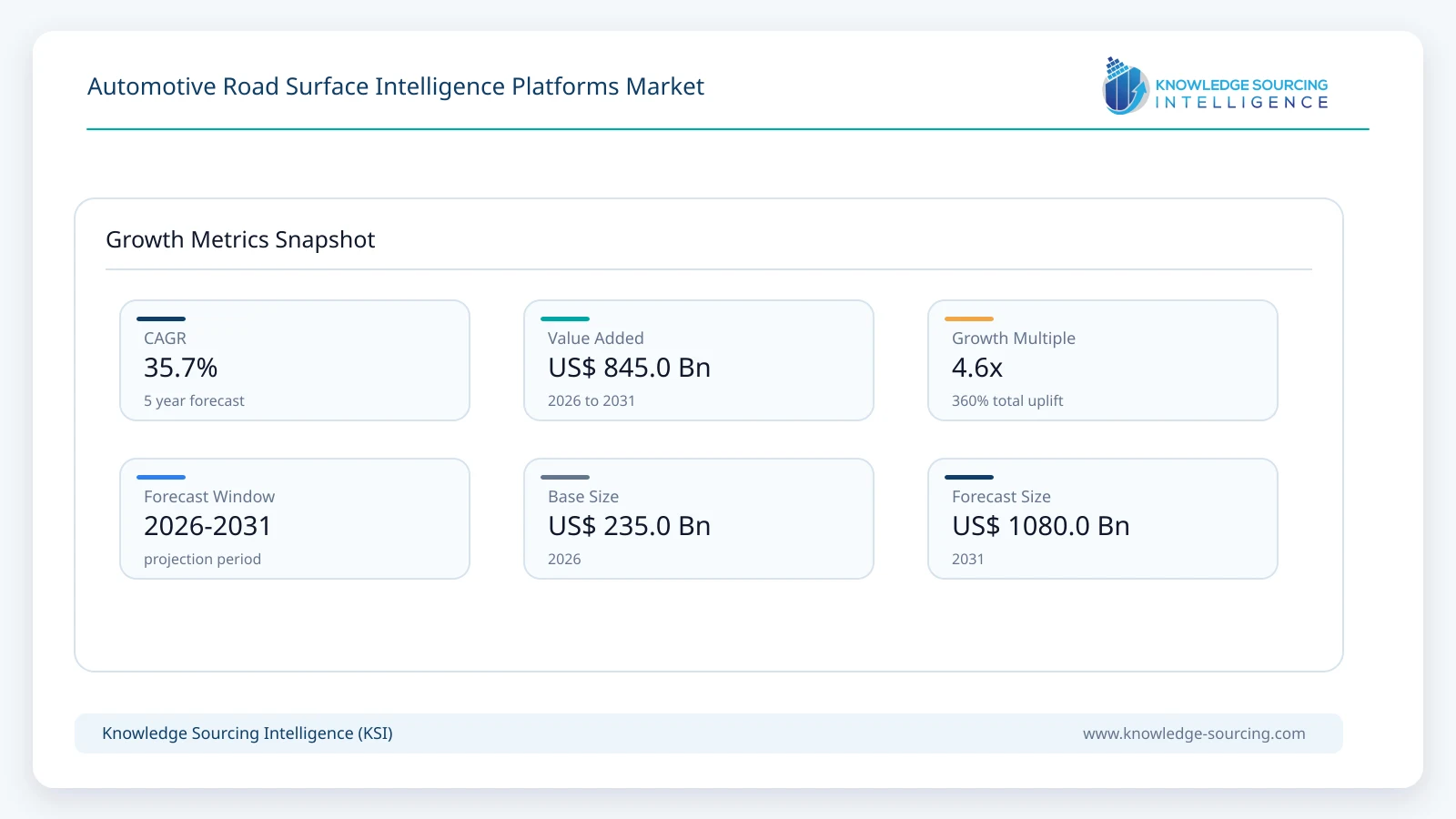
The Automotive Road Surface Intelligence Platforms Market is forecast to grow at a CAGR of 35.7%, reaching USD 1,080.0 million in 2031 from USD 235.0 million in 2026.
Highlights:
- 1The market is projected to rise from USD 235 million in 2026 to USD 1.080 billion in 2031.
- 2Vehicle road-hazard intelligence licenses lead 2026 platform revenue with approximately 34% share.
- 3Grip and slipperiness intelligence is the leading function, supported by road-condition data from large connected fleets.
- 4Europe leads in 2026, while Asia Pacific is modeled to become the largest regional market by 2031.
- 5Government road-maintenance applications are expanding beyond occasional surveys into recurrent condition monitoring.
- 6Data quality, privacy permissions, and repeat observation density determine platform usefulness and buying decisions.
Road intelligence platforms combine observed road grip, pavement condition, and localized environmental data in a common location-aware service that can support driving decisions beyond the sensing range of a single vehicle. Commercial offerings range from connected vehicle hazard subscriptions to cloud APIs for mapping specialists and decision-support dashboards for highway departments. Revenue depends on data quality, repeated coverage, and customer access to actionable road-condition information.
Software-only approaches can use existing braking, stability and suspension signals, while camera and tire-based systems provide additional road detail when needed. The same platform operator may supply embedded warnings to a vehicle manufacturer and condition data to a road agency under separate contracts. NIRA, Bosch, Mercedes-Benz Connectivity Services, ZF and emerging tire-vision collaborators demonstrate these different routes from vehicle observations to purchased services.
Market Overview
Vehicle fleets now provide a continuous source of road-condition observations because wheel-speed, stability-control, steering, suspension, and other signals change when tires encounter ice, wet pavement, or rough surfaces. Road intelligence platforms translate these measurements into map-matched information that can be delivered before another vehicle reaches the affected road section. Platform customers include automakers, navigation and ADAS providers, fleets, highway agencies and municipal road departments.
NIRA Dynamics combines anonymized vehicle dynamics observations with external road-weather inputs to supply localized condition data, while Bosch offers connected map services that combine vehicle reports and weather information. Mercedes-Benz Connectivity Services provides hazard-warning and road-damage datasets derived from consenting connected vehicles. These different commercial models convert continuously refreshed road observations into vehicle software feeds, data access agreements and public-infrastructure applications.
Pirelli and Univrses are developing a combined tire-sensor and camera-based road-monitoring capability, and ZF is linking road-surface detection with vehicle-dynamics functions. Automotive road intelligence therefore spans embedded vehicle processing and wider cloud-based data delivery. The most valuable systems integrate multiple observations, validate event quality, and make information available quickly enough for drivers, control software, or maintenance crews to act.
Market Trends
Crowdsourced Road Condition Maps Are Becoming a Production Service
Connected fleets can identify changes in traction and surface quality before fixed road-weather stations or scheduled surveys would capture the same event. CARIAD reported that more than two million Volkswagen Group vehicles contributed road-condition observations during the 2025/26 European winter, allowing the system to issue localized alerts at scale. For drivers, the value lies in learning about slippery conditions before reaching the hazard rather than relying only on the vehicle's own sensors.
NIRA's platform combines vehicle signals with spatial mapping and external conditions to produce continually refreshed road information. Data coverage improves as participating vehicles repeatedly traverse the same segments, but system suppliers must also correct for unequal vehicle distribution across rural roads and low-traffic routes. This creates demand for confidence scoring and multi-source validation alongside the core alert feed.
Road Damage Analytics Are Expanding Beyond Driver Warnings
High-frequency suspension and body-motion data can reveal potholes, uneven pavement and developing road defects along routes travelled by connected vehicles. Mercedes-Benz's Surface Events offering groups repeated observations into road events with location, intensity and detection-count information. Public agencies can use such information between conventional specialist survey cycles to prioritize inspection and maintenance activity.
NIRA Road Health also links roughness and pavement-condition observations with historical trends and remaining-service-life analysis. This changes the purchasing conversation from an in-car safety feature to an infrastructure data service that can be renewed by a transport authority. Suppliers able to show repeatable measurements and meaningful maintenance outcomes are better positioned than providers that simply generate large volumes of unfiltered road anomalies.
Automakers Are Linking Surface Information to ADAS and Chassis Functions
Condition-aware driver assistance increasingly requires information about the road ahead, not only information from sensors operating at the current wheel contact patch. ZF introduced AI Road Sense in January 2026, combining vehicle signals, camera inputs and, in higher configurations, LiDAR road profiles to support surface-aware chassis behavior. Such systems illustrate how road observations can influence suspension, driving modes and vehicle dynamics.
The market impact depends on where road recognition is processed and who supplies the resulting condition model. A vehicle-side chassis function may use the same raw observation that a cloud provider subsequently aggregates for other drivers or road authorities. Automakers therefore assess integration latency, road-map precision and ownership of data rights when choosing between embedded software and cloud feeds.
Commercial Data Distribution Is Shifting Toward APIs and Multi-Customer Reuse
Vehicle-generated road observations can support several downstream customers when they are securely anonymized and processed into consistent road segments. Mercedes-Benz offers Surface Events and hazard-warning data through connected-service interfaces, while Bosch integrates NIRA Road Surface Alerts into its map services. These arrangements demonstrate that road intelligence can be sold and distributed through an ecosystem rather than only as a factory-installed vehicle feature.
Data customers increasingly require stable application interfaces, quality indicators, predictable update intervals and integration with existing navigation or road-management software. Standardized APIs can reduce the cost of onboarding additional vehicle brands and road authorities, although contracts must define geographic coverage and permissible uses. The result is growing revenue from recurring access to refined condition data rather than from individual raw sensor observations.
Vision and Tire Sensing Are Extending Surface Classification
Tire-road dynamics provide strong evidence about available grip, while forward-facing cameras can locate visual defects and distinguish surface categories before a vehicle passes over them. Pirelli's April 2026 agreement with Univrses combines Cyber Tyre information with AI-based computer vision for road monitoring and potential automated-driving applications. It also builds on an infrastructure-monitoring project introduced in Italy in 2025.
Combining tire, motion, camera, and weather measurements should improve identification of road hazards that a single signal cannot distinguish reliably. The added processing and data-validation burden can nevertheless make such platforms more expensive than software-only approaches based on existing control-system signals. Commercial adoption will favor configurations that demonstrate improved false-alert performance or new road-condition coverage without costly dedicated hardware.
Segment Analysis
By Platform Revenue Offering: Vehicle Road-Hazard Intelligence Licenses
Vehicle-facing road-hazard intelligence is the largest modeled revenue offering in 2026, representing approximately 34% of market value. It includes licensed condition alerts and location-specific road-status information delivered into connected-car services. CARIAD's Local Hazard Information implementation, enhanced by NIRA data, illustrates how a driver-facing warning service can operate across several brands using aggregated fleet signals.
OEM demand is supported by increased connected-car coverage and the ability to add service functions through software rather than new tire or roadway sensors. Commercial value depends on the specific road intelligence function purchased, so broad infotainment, map navigation, and connectivity subscriptions are not treated as equivalent. By 2031, vehicle-facing licenses are modeled as a larger absolute pool because the addressable connected-vehicle population expands.
By Road Intelligence Function: Grip and Slipperiness Intelligence
Grip and slippery-surface information accounts for roughly 38% of the modeled market in 2026 because low friction presents an immediate safety risk and can be detected through existing stability, wheel-speed, and tire-interaction signals. NIRA's connected-fleet service maps friction-related conditions at fine road-segment resolution, while Mercedes-Benz hazard feeds report slippery roads and related incidents from consenting vehicles.
Winter conditions create strong requirements for both advance vehicle alerts and road-authority response, giving suppliers multiple buyers for similar underlying observations. Beyond winter, wet roads, contamination, and aquaplaning risk support year-round use. Revenue growth also depends on extending reliable coverage to roads with lower connected-vehicle traffic.
By Data Acquisition Method: Vehicle Dynamics and Tire Interaction
Vehicle-dynamics signals provide the largest road-data acquisition category because cars already contain the wheel-speed, anti-lock braking, stability, and powertrain measurements required for friction inference. CARIAD and NIRA demonstrate how these existing signals can be transformed into information useful to other vehicles, with no need to install a special road-surface sensor on each participating car.
While this architecture is commercially attractive, an individual vehicle observation may reflect driving style, tire condition or vehicle configuration as well as the road. Fleet-level filtering and external weather measurements are therefore important. Camera and suspension measurements will gain relevance where additional surface detail justifies higher data-processing expenditure.
By Customer Type: Road Authorities and Municipalities
Public road authorities form a distinct demand pool because pavement monitoring, winter service planning and asset maintenance require network coverage rather than an individual vehicle warning. Mercedes-Benz's 2026–2029 Netherlands Road Monitor involvement demonstrates practical road-agency use of vehicle-generated surface and infrastructure data. NIRA's road-health and winter services similarly offer recurring mapping, trend, and operational decision support.
Public buyers generally require usable road-segment records, documented accuracy and integration with established maintenance workflows. Sales cycles can be longer than automotive software procurement, but multi-year programs can support durable data contracts. Road-agency adoption is expected to broaden as operators compare continuous vehicle-generated observations with periodic manual or instrumented road surveys.
Market Drivers
Growth of Connected-Vehicle Observation Fleets
Connected automobiles increasingly generate road-condition evidence as they travel, reducing the need to equip every road segment with fixed instrumentation. CARIAD reported observations from more than two million Volkswagen Group vehicles in 2026, showing that substantial road coverage can be obtained through software and existing vehicle signals.
Larger source fleets improve repeat observations and the timeliness of hazard updates, raising the usefulness of the platform for both motorists and agencies. Providers still need to control measurement bias, but established vehicle connectivity creates a scalable acquisition route for road intelligence.
OEM Demand for Earlier Hazard Recognition
Road hazards such as black ice, standing water, and sudden surface damage can emerge beyond the sensing range of an individual car. Advanced cockpit warnings give drivers time to reduce speed, while navigation and safety software can incorporate hazard locations into trip planning.
Bosch's integration of NIRA alerts and Volkswagen Group's use of Local Hazard Information show how OEMs can add road-specific warning capability through existing connectivity. This supports recurring software purchases without requiring a new roadside sensor network.
Expansion of Data-Led Road Maintenance
Road authorities must locate developing potholes, surface roughness and winter hazards across extensive networks with limited survey and maintenance budgets. Mercedes-Benz provides clustered surface-event data, while NIRA offers historical road-condition trends and network-status reports to improve intervention planning.
Vehicle observations can complement specialist surveys between scheduled inspections and offer rapid feedback on maintenance actions. Agencies that can link condition feeds to measurable operational decisions are more likely to fund ongoing subscriptions and integrations.
Requirements for Condition-Aware Automated Driving
Advanced driver assistance depends on correctly interpreting braking distance and available grip on wet, icy or damaged surfaces. ZF's AI Road Sense demonstrates a road-recognition approach that combines camera and vehicle signals to adapt chassis behavior to changing terrain.
As vehicle software uses more environmental context, road condition inputs can become a purchased layer inside navigation and automated-driving stacks. Adoption depends on validated prediction quality and latency, particularly when vehicle control decisions rely on those inputs.
API-Based Distribution of Reusable Road Intelligence
A single verified road-condition observation can contribute to driver warnings, fleet route decisions and highway maintenance planning when suppliers deliver standardized location-aware information. Bosch, NIRA, Mercedes-Benz and ZF describe interfaces that make such sharing commercially possible.
Reusable feeds allow providers to serve more than one buyer category without reproducing the original data-collection cost for every contract. Buyers increasingly pay for continuity, coverage, interoperability and decision-quality information rather than for isolated sensor readings.
Market Restraints
Uneven Road Coverage and Observation Density
Connected-vehicle observations tend to be concentrated on busy roads and locations with high participation from compatible vehicles. A highly accurate city road map does not guarantee timely coverage on rural links, secondary roads or newly opened routes.
Suppliers must communicate data freshness and confidence and may need external weather inputs or authority data to cover sparse locations. Unequal network coverage can delay purchases where customers require consistent nationwide or regional performance.
False Alerts and Complex Surface Classification
A wheel-slip event may result from worn tires, aggressive driving or vehicle-specific traction control rather than an unexpectedly slippery road. Likewise, a vertical acceleration event may reflect speed bumps or road joints rather than a pothole requiring repair.
Robust classification therefore depends on repeated observations, map matching and vehicle-type normalization. False positives can reduce driver trust or create unnecessary road-maintenance work, increasing validation expenditure.
Privacy, Consent and Data-Sharing Requirements
Road intelligence platforms must handle potentially sensitive connected-vehicle signals while delivering sufficiently precise location and time information to end users. Mercedes-Benz describes consent-based and anonymized data collection for its commercial hazard-warning services.
Automakers and buyers must agree on permitted uses, retention periods, and cross-border transfers before data can support new service contracts. Privacy engineering and contract negotiation can slow multi-OEM pooling even when technical interfaces are available.
Integration Costs Across Vehicle and Road Systems
Vehicle brands use different sensor calibrations, control architectures, and cloud interfaces, making it difficult to turn a common road-surface model into identical measurements from every fleet. Public road authorities also operate varied asset-management systems.
Onboarding typically requires validation, geographic localization, API integration, and service-level commitments. These requirements can lengthen sales cycles and reduce the margin available from smaller data customers.
Competition from Existing Hazard and Weather Information
Navigation services already provide general hazard and weather warnings, and public agencies continue to use road-weather stations, specialist survey vehicles and visual inspection. Road-surface platforms must show that vehicle-derived local grip and road-damage insights improve decisions beyond these established sources.
When a broader map or connected-car subscription bundles related warnings, the incremental price for a separate road intelligence feed may be limited. Providers must establish clear value through higher spatial precision, update speed, or infrastructure-maintenance savings.
Regional Outlook
Europe
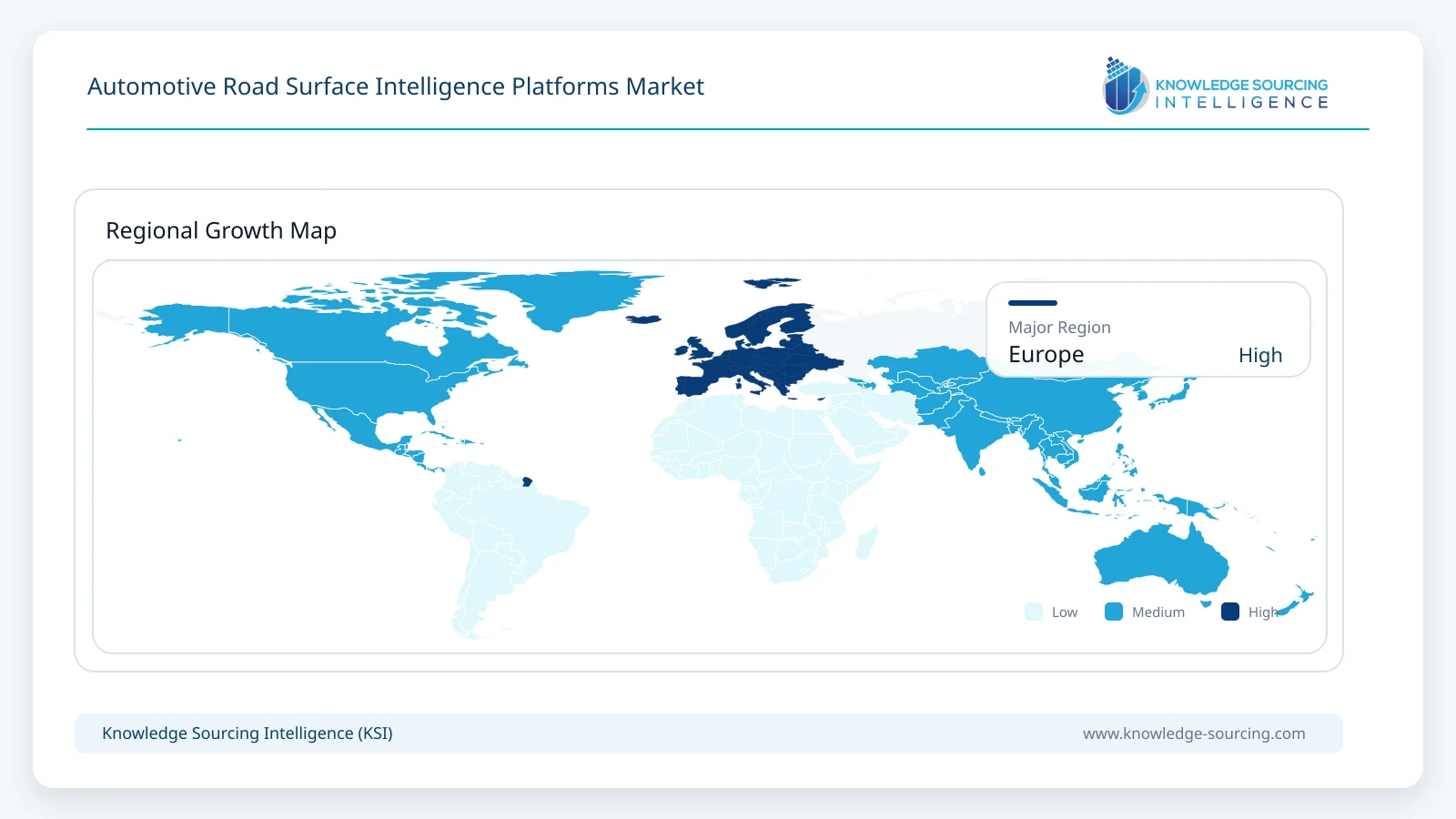
Europe leads the modeled market in 2026 with approximately USD 90 million in road-surface platform revenue, supported by dense connected-vehicle fleets, mature road agencies and suppliers including NIRA, Mercedes-Benz and Bosch. Volkswagen Group's large-scale friction-data system and the Netherlands' continued Road Monitor program provide examples of vehicle-warning and public-infrastructure demand in the same region.
European buyers place high value on winter operations, cross-border hazard information and rigorous data protection, all of which influence platform design and procurement. Germany and the United Kingdom remain important early commercial centers, while wider access to compatible fleet data supports growth across other European roads.
Asia Pacific
Asia Pacific is modeled as the fastest-growing region through 2031 because its large automotive production base and increasing connectivity create opportunities to scale localized road information. China, Japan and South Korea have extensive vehicle-electronics capability, while India and Southeast Asia offer a longer-term market for infrastructure condition monitoring as connected fleets become larger.
Road-surface suppliers must adapt models to different road geometry, road maintenance practices, climate and vehicle fleet composition. Regional revenue is modeled at approximately USD 415 million by 2031, overtaking Europe as road authorities, OEMs and map providers purchase increasingly detailed road-condition services.
Competitive Landscape
The competitive landscape combines vehicle-signal specialists, automotive electronics suppliers, connected-data owners and map-service providers. NIRA Dynamics specializes in tire/vehicle-derived road friction and surface intelligence, while Bosch and CARIAD integrate those observations into larger connected-car systems. Mercedes-Benz Connectivity Services commercializes fleet-generated events directly to external users, showing how an OEM can also become a data supplier.
ZF connects road-condition interpretation with chassis functions and an externally available road-monitoring API. Pirelli and Univrses are building a different capability based on tire sensing and computer vision, while HERE supplies a route for distributing sensor-derived safety information to navigation and mobility services. Michelin Mobility Intelligence participates in neighboring road-risk analytics, where only condition-specific revenue is relevant to this market.
Competition is likely to shift toward verified coverage, accuracy by road segment, rapid updates, secure access and the ability to integrate observations from multiple vehicle brands. Suppliers that offer useful customer workflows rather than raw anomaly streams can earn recurring revenue from public authorities and mapping partners as well as automakers.
Recent Developments
14 October 2026: NIRA Dynamics explained how its Winter Road Insights uses aggregated connected-vehicle grip measurements updated at short intervals, supporting network-level winter maintenance decisions.
1 September 2026: Mercedes-Benz /developers listed Surface Events API version 4.0 as live, expanding an established route for commercial access to fleet-generated road anomalies.
1 July 2026: Mercedes-Benz confirmed continued participation in the Netherlands Road Monitor program for 2026–2029, extending vehicle-generated infrastructure-condition analysis.
19 June 2026: iRAP and NIRA Dynamics announced AiRAP accreditation for NIRA vehicle data covering road condition and skid resistance, strengthening its road-safety assessment credentials.
29 April 2026: Pirelli and Univrses agreed to integrate AI computer vision with Cyber Tyre and disclosed Pirelli’s 30% equity investment, targeting road monitoring and future driving applications.
20 February 2026: CARIAD reported production-scale connected road-grip intelligence from the Volkswagen Group fleet, including sharply higher winter slipperiness alerts.
Market Outlook
Road-surface intelligence platforms should increasingly provide both real-time vehicle guidance and longer-term condition data used to maintain road networks. Cloud-based multi-vehicle mapping remains the principal scaling route because one verified road event can be distributed to multiple drivers or commercial subscribers. OEMs are likely to demand more detailed confidence scores and predictable data latency as surface conditions influence safety and route decisions.
Road-authority analytics should become a larger source of recurring demand as continuous vehicle observations supplement traditional surveys and winter service instruments. Integration with mapping, asset-management and predictive-maintenance software will determine the usefulness of such feeds. Investments in repeated observations, condition validation and customer-specific workflows are likely to matter more than adding new sensor types alone.
Asia Pacific's vehicle and connectivity scale is expected to shift regional demand toward the region by 2031, while Europe remains a major source of established deployments and public-infrastructure use cases. Suppliers with strong multi-OEM data agreements, quality management and privacy controls will be better positioned to convert improved spatial coverage into sustained platform revenue.
Automotive Road Surface Intelligence Platforms Market Scope:
| Report Metric | Details |
|---|---|
| Total Market Size in 2026 | USD 235.0 million |
| Total Market Size in 2031 | USD 1,080.0 million |
| Forecast Unit | USD Billion |
| Growth Rate | 35.7% |
| Study Period | 2021 to 2031 |
| Historical Data | 2021 to 2024 |
| Base Year | 2025 |
| Forecast Period | 2026 – 2031 |
| Segmentation | Platform Revenue Offering, Road Intelligence Function, Road Data Acquisition Method, Platform Deployment Architecture |
| Companies |
|
| Customization Scope | 15% Free Customization included with purchase — Request Custom Breakdown → |
| Sample & Data Access | PDF Sample, Excel Databook & Analyst Briefing — Download Free Sample → |
Market Segmentation
By Platform Revenue Offering
Vehicle Road-Hazard Intelligence Licenses
Commercial Road-Data API Services
Road Authority Condition Analytics
Platform Integration and Validation Services
By Road Intelligence Function
Grip and Slipperiness Intelligence
Pothole and Surface Roughness Monitoring
Localized Road-Weather Intelligence
Predictive Multi-Hazard Road Mapping
By Road Data Acquisition Method
Vehicle Dynamics and Tire Interaction
Suspension and Motion Sensing
Camera and Perception-Derived Observations
Multi-Source Fused Data
By Platform Deployment Architecture
Cloud-Based Swarm Intelligence
On-Vehicle Edge Intelligence
Hybrid Edge-to-Cloud Platform
By Primary Customer Type
Passenger Vehicle OEMs
Commercial Fleets and Logistics Operators
Road Authorities and Municipalities
Mapping and ADAS Technology Providers
By End-Use Application
Driver Warning and Route Safety
ADAS and Automated-Driving Planning
Winter Service Operations
Pavement and Infrastructure Management
By Update and Delivery Mode
Real-Time Event Alerts
Near-Real-Time Condition Feeds
Periodic Infrastructure Analytics
By Geography
North America
United States
Canada
Mexico
South America
Brazil
Argentina
Others
Europe
Germany
United Kingdom
France
Italy
Spain
Netherlands
Nordic Countries
Others
Middle East and Africa
Saudi Arabia
United Arab Emirates
South Africa
Others
Asia Pacific
China
Japan
South Korea
India
Australia
Indonesia
Thailand
Taiwan
Others
Table of Contents
1. EXECUTIVE SUMMARY
1.1. Market Opportunity and Key Findings
1.2. Road Surface Intelligence Market Size, 2026–2031
1.3. Leading Platform and Application Outlook
1.4. Regional Market Opportunity
2. MARKET SNAPSHOT
2.1. Market Overview
2.2. Market Definition
2.3. Scope of the Study
2.4. Market Segmentation
3. BUSINESS LANDSCAPE
3.1. Market Drivers
3.1.1. Growth of Connected-Vehicle Observation Fleets
3.1.2. OEM Demand for Earlier Hazard Recognition
3.1.3. Expansion of Data-Led Road Maintenance
3.1.4. Requirements for Condition-Aware Automated Driving
3.1.5. API-Based Distribution of Reusable Road Intelligence
3.2. Market Restraints
3.2.1. Uneven Road Coverage and Observation Density
3.2.2. False Alerts and Complex Surface Classification
3.2.3. Privacy, Consent and Data-Sharing Requirements
3.2.4. Integration Costs Across Vehicle and Road Systems
3.2.5. Competition from Existing Hazard and Weather Information
3.3. Market Opportunities
3.4. Porter's Five Forces Analysis
3.5. Industry Value Chain Analysis
3.6. Policies and Regulations
3.7. Strategic Recommendations
4. TECHNOLOGICAL OUTLOOK
4.1. Vehicle-Signal Road Condition Estimation
4.2. Swarm Data Fusion and Map Matching
4.3. Surface Event Detection and Pavement Analytics
4.4. Road Weather and Winter Grip Intelligence
4.5. Camera and Tire Data Integration
4.6. Data Quality, Security and API Architecture
5. AUTOMOTIVE ROAD SURFACE INTELLIGENCE PLATFORMS MARKET BY PLATFORM REVENUE OFFERING
5.1. Introduction
5.2. Vehicle Road-Hazard Intelligence Licenses
5.3. Commercial Road-Data API Services
5.4. Road Authority Condition Analytics
5.5. Platform Integration and Validation Services
6. AUTOMOTIVE ROAD SURFACE INTELLIGENCE PLATFORMS MARKET BY ROAD INTELLIGENCE FUNCTION
6.1. Introduction
6.2. Grip and Slipperiness Intelligence
6.3. Pothole and Surface Roughness Monitoring
6.4. Localized Road-Weather Intelligence
6.5. Predictive Multi-Hazard Road Mapping
7. AUTOMOTIVE ROAD SURFACE INTELLIGENCE PLATFORMS MARKET BY ROAD DATA ACQUISITION METHOD
7.1. Introduction
7.2. Vehicle Dynamics and Tire Interaction
7.3. Suspension and Motion Sensing
7.4. Camera and Perception-Derived Observations
7.5. Multi-Source Fused Data
8. AUTOMOTIVE ROAD SURFACE INTELLIGENCE PLATFORMS MARKET BY PLATFORM DEPLOYMENT ARCHITECTURE
8.1. Introduction
8.2. Cloud-Based Swarm Intelligence
8.3. On-Vehicle Edge Intelligence
8.4. Hybrid Edge-to-Cloud Platform
9. AUTOMOTIVE ROAD SURFACE INTELLIGENCE PLATFORMS MARKET BY PRIMARY CUSTOMER TYPE
9.1. Introduction
9.2. Passenger Vehicle OEMs
9.3. Commercial Fleets and Logistics Operators
9.4. Road Authorities and Municipalities
9.5. Mapping and ADAS Technology Providers
10. AUTOMOTIVE ROAD SURFACE INTELLIGENCE PLATFORMS MARKET BY END-USE APPLICATION
10.1. Introduction
10.2. Driver Warning and Route Safety
10.3. ADAS and Automated-Driving Planning
10.4. Winter Service Operations
10.5. Pavement and Infrastructure Management
11. AUTOMOTIVE ROAD SURFACE INTELLIGENCE PLATFORMS MARKET BY UPDATE AND DELIVERY MODE
11.1. Introduction
11.2. Real-Time Event Alerts
11.3. Near-Real-Time Condition Feeds
11.4. Periodic Infrastructure Analytics
12. AUTOMOTIVE ROAD SURFACE INTELLIGENCE PLATFORMS MARKET BY GEOGRAPHY
12.1. North America
12.1.1. United States
12.1.2. Canada
12.1.3. Mexico
12.2. South America
12.2.1. Brazil
12.2.2. Argentina
12.2.3. Others
12.3. Europe
12.3.1. Germany
12.3.2. United Kingdom
12.3.3. France
12.3.4. Italy
12.3.5. Spain
12.3.6. Netherlands
12.3.7. Nordic Countries
12.3.8. Others
12.4. Middle East and Africa
12.4.1. Saudi Arabia
12.4.2. United Arab Emirates
12.4.3. South Africa
12.4.4. Others
12.5. Asia Pacific
12.5.1. China
12.5.2. Japan
12.5.3. South Korea
12.5.4. India
12.5.5. Australia
12.5.6. Indonesia
12.5.7. Thailand
12.5.8. Taiwan
12.5.9. Others
13. COMPETITIVE ENVIRONMENT AND ANALYSIS
13.1. Major Players and Strategy Analysis
13.2. Market Share Analysis
13.3. Mergers, Acquisitions, Agreements and Collaborations
13.4. Competitive Dashboard
14. COMPANY PROFILES
14.1. NIRA Dynamics AB
14.2. Robert Bosch GmbH
14.3. Mercedes-Benz Connectivity Services GmbH
14.4. CARIAD SE
14.5. ZF Friedrichshafen AG
14.6. Pirelli & C. S.p.A.
14.7. Univrses AB
14.8. HERE Technologies
14.9. Michelin Mobility Intelligence
14.10. Tactile Mobility Ltd.
15. APPENDIX
15.1. Currency
15.2. Assumptions
15.3. Base and Forecast Years Timeline
15.4. Key Benefits for Stakeholders
15.5. Research Methodology
15.6. Abbreviations





Frequently asked questions
What is the projected market size for 2031?
The Automotive Road Surface Intelligence Platforms Market is projected to reach USD 1,080.0 million by 2031.
What is the compound annual growth rate (CAGR)?
The Automotive Road Surface Intelligence Platforms Market is forecast to grow at a CAGR of 35.7%.
Which segment leads 2026 platform revenue?
Vehicle road-hazard intelligence licenses lead with 34% share.
Which region will be largest by 2031?
Asia Pacific is modeled to become the largest regional market by 2031.
What is the leading functional driver?
Grip and slipperiness intelligence is the leading function.
What was the market size in 2026?
The Automotive Road Surface Intelligence Platforms Market was USD 235.0 million in 2026.
Cite this report
Knowledge Sourcing Intelligence. (Oct 2026). Automotive Road Surface Intelligence Platforms Market Size, Share & Growth Forecast (2026-2031). https://www.knowledge-sourcing.com/report/automotive-road-surface-intelligence-platforms-market